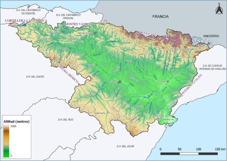
Middle Ebro River. Flood risk management and resilience for cities and citizens.

Contributed by: Rogelio Galván Plaza, María Luisa Moreno Santaengracia, Mario Carreras Fernández, Lorenzo Polanco Fernández, David Gargantilla Cañero, Oficina de Planificación Hidrológica, Confederación Hidrográfica del Ebro

Download story

Summary

The Ebro River Basin has three million inhabitants, approximately one third of whom live in cities and towns along the banks of the middle Ebro. The impacts of flooding affecting these inhabitants are expected to increase with a higher frequency in the number and intensity of floods due to climate change. Citizens have called for improved protection and rehabilitation of riverine areas, indicating the value of the aquatic environment to those living in cities.

The Flood Risk Management Plan developed by the Ebro River Basin Authority in Spain is a framework instrument that covers a whole range of measures for government to implement including urban development, territorial planning, the natural environment, forest management, insurance, hydrology, hydraulics, etc. Among the measures developed in this framework, there are three tools which strengthen the connection between cities and their citizens to be part of the flood management for this part of the Ebro River, increasing awareness and co-responsibility. This includes:

  • The web application “check your risk” allows each citizen to check the risk of flooding of their property
  • The Automatic Hydrological Information System (SAIH, in Spanish) provides real-time data, every fifteen minutes, on rainfall, levels or flows, and a Decision Support System (SAD, in Spanish) offers hydrological forecasts based on weather forecasts.
  • The Ebro Resilience Strategy a framework for collaboration between the different administrations, including the cities and other stakeholders, to work in solidarity and coordination to manage the flood risk of the middle stretch of the Ebro River.

Figure 1: Location of the Ebro basin

Figure 2: Middle stretch of the Ebro, subject of the Ebro Resilience Strategy

Country:

Spain

City and population:

Zaragoza (681,877 inhabitants)
Logroño (152,485 inhabitants)
Tudela (37,042 inhabitants)
Calahorra (24,531 inhabitants) and others (up to about one million inhabitants)

Basin area:

Ebro Basin (85,541 km²)

Problem:

  • Human activities in the middle Ebro valley have become more vulnerable to the effects of floods.

Solution:

  • Implement a new framework for action to increase resilience and improve flood risk management.

1. The Problem

The Ebro River Basin has three million inhabitants, approximately one third of whom live in cities and towns (including Logroño, Calahorra, Tudela and Zaragoza) along the banks of the middle Ebro, being the main ones.

Following a severe flooding event in 1960, the river began to be channelled by means of protective dykes that reduced the mobility of the riverbed, while economic and urban activities occupied the river area. However, at the beginning of the 21st century, damage from floods continued to increase, in part due to channelisation and greater occupation of the flood area both by urbanised and agricultural areas.

The inhabitants of the towns and villages along the banks of the Ebro River perceive the damage caused by floods has increased, and their economic activities have been increasingly threatened. The compensation to those affected by both insurers and administrations has been steadily increasing in recent years. These impacts are expected to increase with a higher frequency in the number and intensity of floods due to climate change. Citizens have called for improved protection and rehabilitation of riverine areas, indicating the value of the aquatic environment to those living in cities.

2. The solution

The European Water Framework Directive provides the regulatory structure to put in place actions to improve the status of water bodies; and the European Floods Directive provides the context to implement measures to reduce the risk of flooding. The Flood Directive enforce European Union member states to carry out Flood Risk Management Plans.

The good practice highlighted are actions coming from the Flood Risk Management Plan developed by the Ebro River Basin Authority in Spain. The Flood Risk Management Plan  is a framework instrument that covers a whole range of measures for government to implement including urban development, territorial planning, the natural environment, forest management, insurance, hydrology, hydraulics, etc (Tomas et al., 2020).The plan is intended to raise awareness of flood risk and promote protective measures among the population and both social and economic actors; improve land planning especially in urban areas; improve predictive capacity; strengthen coordination among public administrations including cities; reduce vulnerability; reduce flood hazards, and improve the environmental condition of water bodies (Tomás et al., 2020).

Among the measures developed in this framework, there are three tools which strengthen the connection between cities and their citizens to be part of the flood management for this part of the Ebro River, increasing awareness and co-responsibility. They are the following:

  1. The web application “check your risk” allows each citizen to check the risk of flooding of their property, simply by indicating the name of the town and their property’s cadastral number. High risk areas are indicated in red, medium in orange and low in yellow. The same application shows information on the flow associated with each zone. These data come from the flood risk maps developed by the Confederación Hidrográfica del Ebro for the Ebro basin territory for the second phase of the development of the Floods Directive.

http://www.chebro.es/PGRI/chequea-tu-riesgo.html

Apart from this application, cities and citizens have access to the entire zoning and therefore to the activities and uses that can be carried out in each of the areas according to flood regulations.

  1. The Automatic Hydrological Information System (SAIH, in Spanish) provides real-time data, every fifteen minutes, on rainfall, levels or flows, and a Decision Support System (SAD, in Spanish) offers hydrological forecasts based on weather forecasts. This information, which is available online to all, supports better decision making, activation of civil protection services and general warnings for the population.

The data of recent past flood events provided on the SAIH website can alert citizens of the potential flood risk and encourages them to also take their own self-protection measures http://www.saihebro.com/saihebro/index.php

  1. The Ebro Resilience Strategy is a framework for collaboration between the different administrations, including the cities and other stakeholders, to work in solidarity and coordination to manage the flood risk of the middle stretch of the Ebro River.

The aim of this Strategy is to promote actions that reduce the impact of floods in the most at-risk sections of the middle stretch of the Ebro River, implementing measures that in turn contribute to improve the river ecological health. It also aims to improve the population’s capacity to respond to flooding events

The vision for the future is for which economic activities and towns to coexist with a river Ebro in a good state of conservation, without the inevitable floods causing significant damage. This strategy provides an agreed framework  for the various actors to come together to achieve these goals.

https://ebroresilience.com/

Figure 3. Control room of the Automatic Hydrological Information System

Some stakeholders continue to think in terms of the traditional vision of flood protection at all costs and through built infrastructure. But there is a growing understanding that this approach has undesirable effects on both safety, (increasing flow velocity or creating a false feeling of complete safety) and the environment (affecting hydromorphology and living species and as a result causing deterioration of water bodies).

Consequently, cities are increasingly aware of the need for urban development that takes into account flood risk and the legal requirements currently in force. There is also appreciation of the benefits of the natural river environment being integrated into the urban landscape, such as improved liveability, recreation areas, better water, air and soil quality, temperature regulation, and reducing noise pollution.

3. Lessons Learned

Implementation of the Flood Risk Management Plan has been a gradual process where lessons learned have been used to improve the process and response.

First lesson: Real time information and forecast in the case of floods are essential for citizens.   

The Automatic Hydrological Information System started to be implemented during the 1990s and has undergone continuous improvement. A specific improvement has been the incorporation of a Decision Support System that include simulation models providing hydrological forecasts on which to base and advance decision-making. Likewise, making all this information available to the public via the Internet in real time has substantially improved the usefulness of this tool.

Currently, with each flood event, the use of the web application has multiplied, reinforcing citizens’ knowledge and their likelihood of taking protective measures. Access to forecasts is also essential, although in some cases it has generated an excess of confidence in their certainty, so it is necessary to improve the transmission of this information for a good understanding of the uncertainty inherent in the prediction resulting from the model simulation.

Second lesson: Citizens need to know clearly what their risk of floods is.

The Flood Risk Management Plan stems from a European directive approved in 2007. The first plan was approved in 2016 and is currently being revised and updated every six years. Self-protection is a cornerstone of the plan, and is essential to raise awareness and co-responsibility of citizens to protect themselves from floods. People need to know how exposed their properties are, and in this context, the “check your risk” tool proves its worth.

Third lesson: Participation is a key to success

The Ebro Resilience Strategy was launched in 2017 specifically for the middle section of the Ebro River and is currently being implemented. Previous actions include hydraulic studies, vulnerability analysis of facilities, and workshops to raise awareness and increase participation have been carried out. Further activities in the pipeline. The participatory approach to implementing the strategy by the basin organization has led to a shared vision that actions must strike a balance between the conservation and restoration of the watercourse, and the mitigation of the effects of floods. However, in certain areas primarily related to farming, a more traditional vision remains, linked to built infrastructure and dredging of the river. Participation has helped in the definition of the specific measures (dykes to be moved further from the river, creation of flood areas, permeabilization…).


What are the drivers for action?

Extreme Events Declining water quality Water availability
☐Public health hazards


☐ High operating costs


☐ Water supply disruption


x Damage to infrastructure ☐ Loss of credibility and trust ☐ Constraints to growth


x Economic activities and supply chain disruption ☐ Environmental, cultural and health impacts ☐ Declining quality of life

For more information on the Drivers for Action visit the Action Agenda for Basin-Connected Cities.

Pathways for Action

Assessment Planning Implementation
X Investment in data & information systems


x Risk-based approach to planning


x Integration of natural infrastructure


☐ Linking traditional water management with science


☐ Water allocation mechanisms


☐ Economic and financing mechanisms


☐ Invest in values to motivate water decision-making x Stakeholder participation in planning and management ☐ Building partnerships from catchment to tap
☐ Aligning urban development with basin management


X  Digital Technologies


For more information on the Pathways for Action visit the Action Agenda for Basin-Connected Cities.

About the Ebro River Basin Authority

The Ebro River Basin Authority (Confederación Hidrográfica del Ebro in Spanish) is the body of the Ebro river basin. Its mission is to provide integrated management of water resources within the natural framework of the river basin.

It depends on the Ministry for Ecological Transition and the Demographic Challenge of the Spanish Government, but its participation bodies include the autonomous communities (regions), water users and others.

Figure 4: Flooding 2015, middle stretch of the Ebro River.